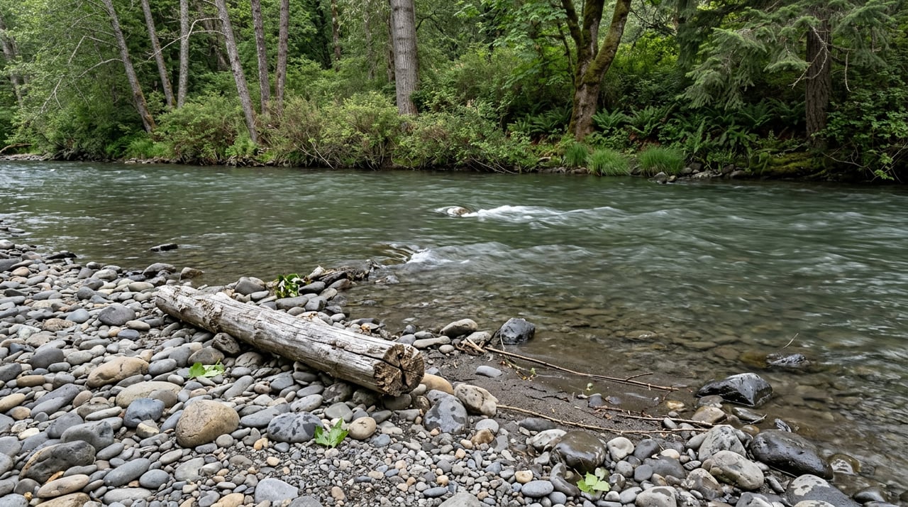
Imagine stepping out with a mug of coffee and watching the Umpqua move past, glassy in summer and quick with winter rain. If you have been picturing a riverfront cabin, a working timber parcel, or a small pasture with views, you are not alone. Owning land along the Umpqua in Douglas County blends recreation and privacy with a real set of rules and responsibilities. In this guide, you will learn what river parcels look like here, how permits and setbacks work, and the key checks to run before you buy. Let’s dive in.
What “Umpqua frontage” really means
Not every river property is the same. Along the Umpqua you will find a few common parcel types:
- Direct riverfront parcels with bankline frontage and immediate water access.
- Upland or river‑view parcels that sit above the river with broad vistas.
- Small acreage pastures or hobby farms that touch the riparian edge.
- Larger working timber parcels, often intermingled with federal lands.
In places, private lands are adjacent to public holdings, especially near the North Umpqua Wild and Scenic corridor. That mix shapes access, privacy, and the feel of the landscape. For context on the corridor’s recreation and resources, explore the North Umpqua Wild and Scenic overview from the Bureau of Land Management. You can learn more on the BLM’s North Umpqua page at North Umpqua Wild & Scenic River overview.
Zoning and the county’s land use framework matter. Rules for building, allowed uses, and lot creation differ between resource zones, rural residential areas, and urban unincorporated pockets. Always confirm parcel‑specific rules with Douglas County planning and the Land Use & Development Ordinance.
Recreation and daily rhythms
If you love water, the Umpqua delivers. The system supports salmon and steelhead runs and a mix of native and game fish. The North Umpqua is well known for seasonal wild steelhead fly‑fishing and whitewater. Run timing and rules shift by season, and hatchery versus wild fish regulations are different. Before you plan a season of casting or floating, check current regulations and local conditions.
Public access on the river is part of daily life in the basin. Douglas County, state agencies, and BLM manage a network of ramps and day‑use sites. Conditions at boat ramps can change with high water or maintenance work, so confirm the current status of your planned put‑in and take‑out.
Wildlife is part of the backdrop. Expect waterfowl, osprey, eagles, otter, and deer in riparian areas. That is a lifestyle plus, and it can also shape permits where sensitive habitat or nests are present. Local stewardship groups and land trusts often partner on habitat projects and can be good neighbors and resources.
Building near the water: rules you will meet
Setbacks and the Riparian Vegetation Corridor
Douglas County applies a Riparian Vegetation Corridor Overlay to many stream banks. A key rule to know is the 50‑foot horizontal building setback from the bankline for covered streams. Variances are possible in some cases after consultation with state fish and wildlife staff, but the 50 feet is the standard baseline. You can review the county overlay language at the county’s ordinance section on Riparian Vegetation Corridor Overlay and 50‑foot setback.
In‑water work, docks, and bank stabilization
In Oregon, the state manages public rights on many river beds and banks. If you plan to place a dock, stabilize a bank, add fill, or do any work below the ordinary high water mark, expect review by the Department of State Lands and, in many cases, a removal/fill permit. Some projects also require coordination with the Corps or DEQ. The safe rule is simple. Do not start in‑water or bank work until you speak with DSL. Learn more about public use and permitting at the Oregon DSL page on public use of state‑owned waterways and permits.
Floodplain mapping and insurance
Parts of the Umpqua corridor fall within FEMA Special Flood Hazard Areas. That affects building elevation requirements, county permits, and lender flood‑insurance rules. Maps change over time, so pull the current Flood Insurance Rate Map for your parcel and check for any preliminary changes. Douglas County provides local guidance on its floodplain program.
Working forests, farm edges, and timber income
Many Umpqua‑area parcels include or border active forestland. In Oregon, timber operations on private forestland are regulated by the Oregon Forest Practices Act. Before building or improving logging roads, using power‑driven machinery, applying some pesticides, or harvesting, landowners and operators generally must file a Forest Practices Notification with the Oregon Department of Forestry. Streamside protections are set in administrative rules, and procedures can change over time, so check current guidance. A practical primer is available from OSU Extension at Selling Logs from Your Property.
Special assessment for forestland
Forestland and Small Tract Forestland programs can change how your property is taxed in exchange for forest use commitments. These programs may also add taxes at harvest. Enrollment rules, minimum acreages, and potential rollback penalties are specific, and they can materially affect your annual costs and harvest decisions. Review current program guidelines at the Oregon Department of Revenue’s overview of Forestland special assessment programs and confirm with the county assessor.
Water, wells, and septic
Many river‑area properties rely on private wells and onsite wastewater systems. Septic feasibility depends on soil, slope, and separation to groundwater or the stream, and it is a common limiting factor for new homes or additions. The county’s onsite wastewater program performs site evaluations, issues permits, and provides checklists you can use early in due diligence. Start with the county’s On‑Site Wastewater page.
Surface water rights and stored water are managed by the Oregon Water Resources Department. Water rights do not automatically transfer with a deed. If irrigation or diversion is part of your plan, confirm water rights records and speak with the local watermaster about reliability during low flows. Domestic well rules exist for groundwater use, and critical groundwater areas have added limits. Get clear on your water position before you close.
Access, easements, and roads
Many river parcels are reached by private roads or historic resource roads. The county allows private‑road approvals, but it often requires recorded easements, maintenance agreements, and minimum standards for emergency access. Before you make an offer, verify how you legally access the parcel, who maintains the road, and whether upgrades will be required for a building permit. The county’s Land Divisions chapter outlines private‑road and access standards. Review the relevant section in the Douglas County Land Divisions standards.
Budget and ownership costs
Your cost profile on the river can include more than the purchase price:
- Flood insurance if the home site is in a mapped hazard area.
- Higher sitework costs for riverbanks or steep slopes.
- Driveway, culvert, or bridge improvements for access across creeks.
- Utility extensions on remote parcels.
- Forest practices notifications, monitoring, or professional support for timber operations.
Build time and budget for geotechnical checks, septic evaluations, permits, and agency consultations where in‑stream or near‑stream work is part of your plan.
Smart due diligence checklist
Use this quick list to confirm the big items before you go under contract:
- Flood risk and maps. Pull the current FEMA Flood Insurance Rate Map and check for preliminary map changes. If the parcel is in a Special Flood Hazard Area, price an elevation certificate and potential mitigation. Start at the FEMA Map Service Center.
- Riparian boundary and setbacks. Ask for a site plan showing the bankline and whether any planned improvements fall within the county’s Riparian Vegetation Corridor Overlay. See the county overlay standard and 50‑foot rule here: Riparian Vegetation Corridor Overlay.
- Septic feasibility. Request septic records from the seller and talk with Douglas County On‑Site Wastewater about a site evaluation or soil logs if you plan to build. Use the county’s On‑Site Wastewater resources.
- Wells and water. Obtain well logs and, if surface diversion matters, confirm water rights with the Oregon Water Resources Department and the local watermaster. Ask about historic curtailments.
- Easements and access. Pull title and recorded easements. Confirm that the access road meets private‑road standards and whether the county will require any upgrades. The standards live in Douglas County Land Divisions.
- Timber and taxes. Ask the assessor if the property is enrolled in Forestland or Small Tract Forestland special assessment and whether harvest covenants exist. Review the state’s Forestland special assessment programs.
- Permits for planned uses. Identify early which permits you will need for docks, bank work, road upgrades, or stream‑adjacent structures. Start with DSL’s page on public use and permits and confirm county floodplain and planning requirements at the Douglas County Floodplain Program.
- Timber operations. If harvest or road work is likely, review current guidance on notifications and streamside protections. OSU Extension’s overview is a good primer: Selling Logs from Your Property.
Local contacts and resources
- Douglas County Planning and Floodplain Program for permits and flood mapping.
- Douglas County On‑Site Wastewater for septic evaluations and permits.
- Oregon Department of State Lands for in‑water work and removal/fill permits.
- Oregon Department of Forestry and OSU Extension for forest practices notifications and landowner guides.
- Oregon Water Resources Department and the local watermaster for water rights and curtailment history.
Is Umpqua riverfront right for you?
Umpqua property rewards owners who plan ahead. If you pair a clear vision for how you want to use the land with early conversations about setbacks, water, access, and floodplain, the river will give you a lifetime of quiet mornings and seasonal rhythms. With the right due diligence, you can protect habitat, enjoy recreation, and build in a way that fits Douglas County’s rules and your goals.
Place your dreams in our hands. If you want expert help evaluating timber value, riparian constraints, access, and marketing strategy for a purchase or sale, reach out to David Brinker. Our team brings multigenerational timber knowledge and modern, content‑first marketing to Western Oregon land, including riverfront and timber parcels in Douglas County.
FAQs
What is the building setback from the Umpqua River in Douglas County?
- Douglas County applies a Riparian Vegetation Corridor Overlay with a standard 50‑foot horizontal setback from the bankline on covered streams; variances may be possible after consultation with fish and wildlife staff, so confirm parcel specifics with planning.
Do I need a permit to add a dock or stabilize my riverbank on the Umpqua?
- In most cases, yes; the Oregon Department of State Lands reviews in‑water and bank work, and many projects require a removal/fill permit and possibly other agency coordination, so contact DSL before starting.
How does floodplain mapping affect Umpqua River properties in Douglas County?
- If a parcel lies in a FEMA Special Flood Hazard Area, county permits may require elevation or other standards, and lenders often require flood insurance, so check the current map and any preliminary updates before you buy.
Do water rights automatically transfer when I buy Umpqua River property?
- No; water rights are administered by the state and do not transfer with the deed by default, so verify rights with the Oregon Water Resources Department and speak with the local watermaster about reliability and curtailment history.
What rules apply if I plan to harvest timber on my Douglas County river parcel?
- Private forest operations are regulated under the Oregon Forest Practices Act; before using power‑driven machinery, improving roads, or harvesting, file a Forest Practices Notification and follow current streamside and protection rules.